News
KORE Mining Generates Resource Expansion Drill Targets for Long Valley Gold Project
January 30, 2020
Vancouver, BC January 30, 2020 - KORE Mining Ltd. (TSXV: KORE | OTCQB: KOREF) (“KORE” or the “Company”) is pleased to announce results from H2 2019 exploration programs at the Long Valley gold project (“Long Valley” or “Project”) that defined a new exploration strategy for both oxides and sulphides and generated high priority drill targets.
Highlights
- Tested new exploration strategy, opening potential for resource expansion and new discoveries
- Generated data-driven, high priority oxide gold drill targets
- Defined clear targets for drilling sulphide “feeder” structures
Next Steps (H1 2020)
- Apply new exploration strategy to remainder of current deposit (Q1 2020)
- Complete ground geophysics on northern half of deposit (underway)
- Complete re-logging and multi-element analysis of historic drilling
- Develop drill program for highest priority targets and commence permitting (late Q1 2020)
Scott Trebilcock, President and CEO of KORE, stated, “Long Valley is a large, intact epithermal gold deposit historically drilled for near surface oxide gold, leaving the underlying sulphides un-tested.” Mr. Trebilcock continued, “KORE’s exploration team developed a new exploration strategy for both oxides and sulphides and looks forward to testing the highest priority targets.”
In H2 2019, the KORE exploration team re-logged 232 of 896 drill holes, conducted geological mapping, and collected rock and soil samples. The team also conducted two lines of ground induced polarization (“IP”) and magnetic geophysics coinciding with drill holes that were re-logged and soil sampling lines. The objective of the work was to prove up a new exploration strategy, testing it against known mineralization and generate drill targets. Figure 1 shows the location of the IP geophysics surveys and cross sections.
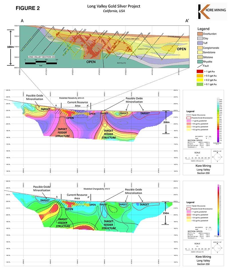
Figure 2, Cross-Section 250 attached to this release, shows the current oxide mineralized area as a chargeability low. Immediately below the current oxide mineralization is a resistivity high, thought to be a feeder structure for the mineralization. Using this model, there are four new near surface oxide targets outlined by chargeability lows and two sulphide feeder structures, outlined by resistivity highs. Near surface oxide targets are coincident with anomalous gold in soil sampling.
Figure 3, Cross-Section 600 is available on KORE’s website by clicking here. The cross-section again shows current oxide mineralization as a chargeability low that is above a resistivity high, thought to be a feeder structure for the mineralization. There appear to be four near surface oxide targets outlined by chargeability lows and three sulphide feeder zone targets, outlined by resistivity highs. Near surface oxide targets are coincident with anomalous gold in soils and rock outcrop sampling.
Figure 4 and 5, Soil Geochemistry and Rock Geochemistry Maps is available on KORE’s website by clicking here. Anomalous gold in soils, gold in rocks, and mapped alteration of surface outcrop, significantly expand the exploration footprint of the deposit, well beyond the current limits of drilling, creating numerous potential areas for oxide gold mineralization expansion. The on-going additional ground geophysics lines will enhance the oxide targeting and potential for more sulphide feeder zone targets.
About Long Valley Gold Project
Long Valley is a 100% owned epithermal gold project located in Mono County, California. Within the Project, is the Long Valley deposit, an intact epithermal gold deposit (“Deposit”) with a large 2.5 by 2 kilometer oxide gold footprint. A total of 896 holes have been drilled on the Project, the majority being completed by reverse circulation with lesser core, rotary and air track. Figure 1 shows the claims, drill collar locations and mineralized area.
The current mineral resource estimate is 1,247,000 ounces of Indicated gold and 486,000 ounces of Inferred gold from 66.8 million tonnes of 0.58 grams per tonne and 23.6 million tonnes of 0.65 grams per tonne, respectively. The mineral resource consists of oxide, transition and sulphides. The estimate was prepared Neil Prenn, P.E., and Steven Weiss, C.P.G. of Mine Development Associates with an effective date of November 15, 2019. More information is available in the technical report filed on www.sedar.com and on KORE’s website at www.koremining.com.
The Long Valley deposit is an intact low sulphidation epithermal gold/silver deposit, hosted within a melange of fine to coarse volcanogenic sedimentary lithologies. Mineralization at the Long Valley deposit has developed due to a combination of deep-rooted fault structures and a resurgence of rhyolite within an active caldera. The Hilton Creek Fault structure transects and served as a fluid conduit for interaction with the underlying hydrothermal system, while the rhyolite resurgence caused brittle fracturing of sediments and created voids or traps for mineralization and gold deposition. The combination of these factors yields strongly altered kaolin and quartz-hematite zones that are the primary host for gold mineralization.
Detailed Results and Conclusions
Historic drill core re-logging included multi-element analysis by XRF and short-wave infrared (“SWIR”) spectroscopy. The analyses enable data-driven determination of the mineralized and un-mineralized alteration mineral assemblages. Key observations from core re-logging:
- Hilton Creek Zone appears partially oxidized to the base of drilling opening potential for further oxides at depth;
- South Zone has numerous open prospective areas at depth and between drill holes; and
- SWIR mineral analysis concluded that Dickite and Illite were the key mineralization-related alteration minerals and can be used to target exploration.
Key observations from bedrock mapping, rock and soil sampling:
- Spatial relationship between intense kaolin and quartz-hematite alteration zones at the unconformity contact between the rhyolite and volcaniclastic sedimentary rock
- Anomalous gold in rock and soil samples occurs along traces of the Hilton Creek Fault in areas that have not been drill tested, representing important targets within the claim group
Field and drilling observations point to a mineralization model controlled by:
- Positioning of deep-rooted fault or “feeder” structures;
- Well-developed alteration and fracture network at the rhyolite dome front; and
- Stratigraphy permissible to quench and trap hydrothermal fluid (i.e. sandstone/tuff).
An implication of deep-rooted fault systems in low sulphidation epithermal systems is that mineralization can occur at all levels between the magmatic source and the surface. Low sulphidation epithermal systems typically form distal to magmatic sources when compared to other epithermal system types. Presuming a structural or lithological ‘trap’ were present at lower levels in the stratigraphy closer to the magmatic source; it is theorized that sulphide-type mineralization could be present at depth along and adjacent to faults.
Key observations from ground (IP) geophysics:
- High resistivity anomalies correspond with the Hilton Creek Fault and relatively high grade gold mineralization;
- Low chargeability anomalies correlate directly with the known gold-oxide zone; and
- High chargeability anomalies occur marginal to the Hilton Creek Fault.
In general, resistivity delineates the fault system and chargeability differentiates oxide vs. sulphide mineralization potential at depth. This geophysical ‘fingerprint’ of the deposit has resulted in promising new prospective zones for oxide and sulphide mineralization types. The new geological model of exploration coupled with results from geophysics, bedrock mapping and soil and rock geochemistry has generated data-driven, drill-ready targets supported by all four data sets (see Figures 1-5).
About KORE
KORE is 100% owner of a portfolio of advanced gold exploration and development assets in California and British Columbia. KORE is supported by strategic investors Eric Sprott and Macquarie Bank who, together with the management and Board own 66% of the basic shares outstanding. Further information on KORE and its assets can be found on the Company’s website at www.koremining.com and at www.sedar.com, or by contacting us as moc.gninimerok@ofni or by telephone at (888) 407-5450.
On behalf of KORE Mining Ltd
”Scott Trebilcock”
Chief Executive Officer
(888) 407-5450
Technical information with respect to Long Valley deposit and project contained in this news release has been reviewed and approved by David S. Smith, CPG, who is KORE’s designated independent qualified person for the purposes of this news release.
This news release does not constitute an offer to sell or a solicitation of an offer to sell any KORE common shares in the United States.
Neither the TSX Venture Exchange nor its Regulation Services Provider (as that term is defined in the policies of the TSX Venture Exchange) accepts responsibility for the adequacy or accuracy of this release.
Cautionary Statement Regarding Adjacent Properties and Forward-Looking Information
This news release contains forward-looking statements relating to the future operations of the Company and other statements that are not historical facts. Forward-looking statements are often identified by terms such as "will", "may", "should", "anticipate", "expects" and similar expressions. All statements other than statements of historical fact, included in this release, including, without limitation, statements regarding the future plans and objectives of the Company are forward-looking statements. Such forward-looking statements, and any assumptions upon which they are based, are made in good faith and reflect our current judgment regarding the direction of our business. Management believes that these assumptions are reasonable. Forward looking information involves known and unknown risks, uncertainties and other factors which may cause the actual results, performance or achievements of the Company to be materially different from any future results, performance or achievements expressed or implied by the forward-looking information. For further information on the Company’s Long Valley Project, please see the Company’s NI 43-101 Technical Report dated November 15, 2019, entitled “Amended Technical Report and Resource Estimate for the Long Valley Project, Mono County, California, USA” filed on the Company’s website and also available under the Company’s issuer profile on www.sedar.com.
Such factors include, among others: risks related to exploration and development activities at the Company’s projects, and factors relating to whether or not mineralization extraction will be commercially viable; risks related to mining operations and the hazards and risks normally encountered in the exploration, development and production of minerals, such as unusual and unexpected geological formations, rock falls, seismic activity, flooding and other conditions involved in the extraction and removal of materials; uncertainties regarding regulatory matters, including obtaining permits and complying with laws and regulations governing exploration, development, production, taxes, labour standards, occupational health, waste disposal, toxic substances, land use, environmental protection, site safety and other matters, and the potential for existing laws and regulations to be amended or more stringently implemented by the relevant authorities; uncertainties regarding estimating mineral resources, which estimates may require revision (either up or down) based on actual production experience; risks relating to fluctuating metals prices and the ability to operate the Company’s projects at a profit in the event of declining metals prices and the need to reassess feasibility of a particular project that estimated resources will be recovered or that they will be recovered at the rates estimated; risks related to title to the Company’s properties, including the risk that the Company’s title may be challenged or impugned by third parties; the ability of the Company to access necessary resources, including mining equipment and crews, on a timely basis and at reasonable cost; competition within the mining industry for the discovery and acquisition of properties from other mining companies, many of which have greater financial, technical and other resources than the Company, for, among other things, the acquisition of mineral claims, leases and other mineral interests as well as for the recruitment and retention of qualified employees and other personnel; access to suitable infrastructure, such as roads, energy and water supplies in the vicinity of the Company’s properties; and risks related to the stage of the Company’s development, including risks relating to limited financial resources, limited availability of additional financing and potential dilution to existing shareholders; reliance on its management and key personnel; inability to obtain adequate or any insurance; exposure to litigation or similar claims; currently unprofitable operations; risks regarding the ability of the Company and its management to manage growth; and potential conflicts of interest.
In addition to the above summary, additional risks and uncertainties are described in the “Risks” section of the Company’s management discussion and analysis for the interim period ended September 30, 2019 prepared as of November 28, 2019 available under the Company’s issuer profile on www.sedar.com.
Forward-looking statements contained herein are made as of the date of this news release and the Company disclaims any obligation to update any forward-looking statements, whether as a result of new information, future events or results, except as may be required by applicable securities laws. There can be no assurance that forward-looking information will prove to be accurate, as actual results and future events could differ materially from those anticipated in such statements. Accordingly, readers should not place undue reliance on forward-looking information.
There is no certainty that all or any part of the mineral resource will be converted into mineral reserve. It is uncertain if further exploration will allow improving the classification of the Indicated or Inferred mineral resource. Mineral resources are not mineral reserves and do not have demonstrated economic viability.
Figure 1 – Plan with Geology and Section Locations
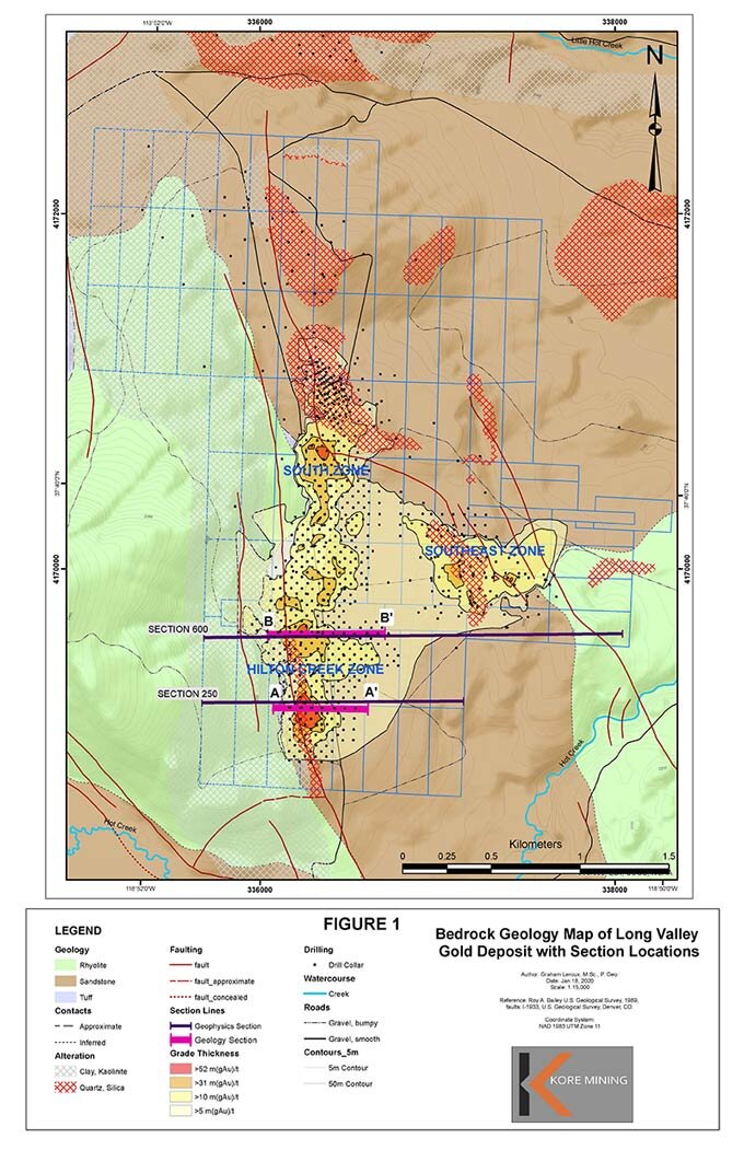
Figure 2 – Section 250 with Oxide and Sulphide Feeder Structure Targets
A full set of high-resolution Figures including both sections, rock and soil sampling are available on KORE’s website here (or copy and paste this into your browser: https://www.koremining.com/pr/exploration-highlights/).